Friday, November 30, 2012

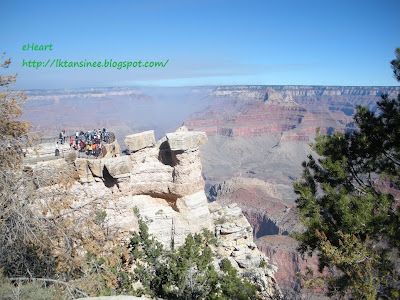
US - Grand Canyon at South Rim


We went in South Entrance Station near Tusayan,AZ, where we stayed last night.


From South Entrance driving to Desert View, the closest viewpoint toEast Entrance Station.


The staircase up to top of tower.


The decorated walls inside the tower.


Window view from top of tower.


In fact, last night we already drove through from East to South Entrance (about 20 miles?), but it was nighttime and we couldn't see anything. 


We drove South - East, then East - South again, stopped at Navajo Point and Lipan Point.


Tusayan Museum and Ruins.


My shoes are loyal and have been many places with me the past five years.  I love them, but am afraid to say good-bye to them soon. 


Then to Grandview Point, Mather Point, Yavapai Point. 


We missed Yaki Point because the driveway was blocked.  Only shuttles were allowed to go there, and we were not sure whether the shuttle line was still running in November. 


South Rim Canyon's model.


We parked the car near Bright Angel Trailhead to take the shuttle to all the viewpoints.


Our shadow.
The shuttle comes every 15 minutes. 
The end viewpoint is named Hermit's Rest. 


"Some visitors asked me to take them to the Skywalk, where is the stop?" one of shuttle's drivers said, "Skywalk is about a 5 hour drive to the East Rim of the Grand Canyon, and costs about $80 per person."


Tuesday, November 27, 2012

US - Arches National Park


A store in the mountain in Hanksville, UT. Cool!


Landmarks in Arches National Park named Three Gossips on the left and Sheep Rock on the right.


Balanced Rock


 Arch named North Window


Arches named North Window and South Window
They looked like eyes.


Turret Arch.
Hiking trail 1 mile round trip for The Windows and Turret Arch.


Skyline Arch


This tiny old trailer parked was driving very slowly in front of us, but we stopped at some viewpoints on the way. When we arrived at Devils Garden Trailhead at the end of the road, it was there.


Hiking trail starts from Devils Garden trailhead to Tunnel Arch.


Then to Pine Tree Arch.


 Then to Landscape Arch.


Heading to Double O Arch, we found the trail is more difficult, we almost gave up.


Steep, narrow, slippery rock surfaces, some areas we didn't know which way the trail went, until we saw the rock cairns marking the way. 


After 4.2 miles round trip, we finally got to see Double O Arch.
We didn't continue to Dark Angel at the end of the trail, that might have added 2 miles round trip?


So, we hiked back on the trail.
Nature's art! What does it look like?


Then to Partition Arch.


Then to Navajo Arch, and back to Devils Garden Trailhead carpark.


We ran out of time, so we didn't go on the 3 mile trail to reach Delicate Arch, but we went 0.5 miles and had a far view at Lower Delicate Arch Viewpoint. 


A beautiful deer in Arches NP.
We drove to Grand Canyon South Rim to stay the night.


Saturday, November 24, 2012

US - Capitol Reef National Park


A natural picture in back of the hotel room.


What a miraculous artist, her name is Nature!


Petroglyphs (carvings on rock walls.)


Tuesday, November 20, 2012

US - Bryce Canyon National Park


Red Canyon on National Scenic Byway 12


Fairyland Point, the first viewpoint before heading to Bryce Canyon visitor center.


Sunrise Point


 Sunset Point


We hiked Navajo loop at Sunset Point.


Two Bridges at Navajo loop trail. 


The 1.3 miles trail took us about 2 hours.


Inspiration Point


Bryce Point


Sunrise, Sunset, Inspiration, and Bryce points encircle Bryce Amphitheater, the biggest natural amphitheater in the park.


Viewpoint named Natural Bridge.


This beautiful blue bird was flying around Bryce Canyon. 

After that we drove to Torrey for the night.

Google